August 2018 Residents’ Association meeting
Draft July minutes and agenda TBC (usually a week beforehand). Check back soon!
Draft July minutes and agenda TBC (usually a week beforehand). Check back soon!
After the success of this event at the last Local Body Elections we are doing it again. Candidates for PCC Mayor, Parirua Maori Ward, Pauatahanui General Ward and GWRC Porirua-Tawa Ward have been invited to introduce themselves to the community then face up to questions (feel free to send a question to secretary@pukeruabay.org.nz but do indicate if it’s aimed at Mayoral, Regional or PCC candidates).
The meeting will be in the School and Community Hall starting at 7 pm and finishing at 9 pm with the opportunity to mingle and talk more to the candidates after the Q & A session.
If you’re inclined bring a plate.
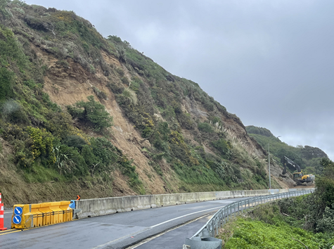
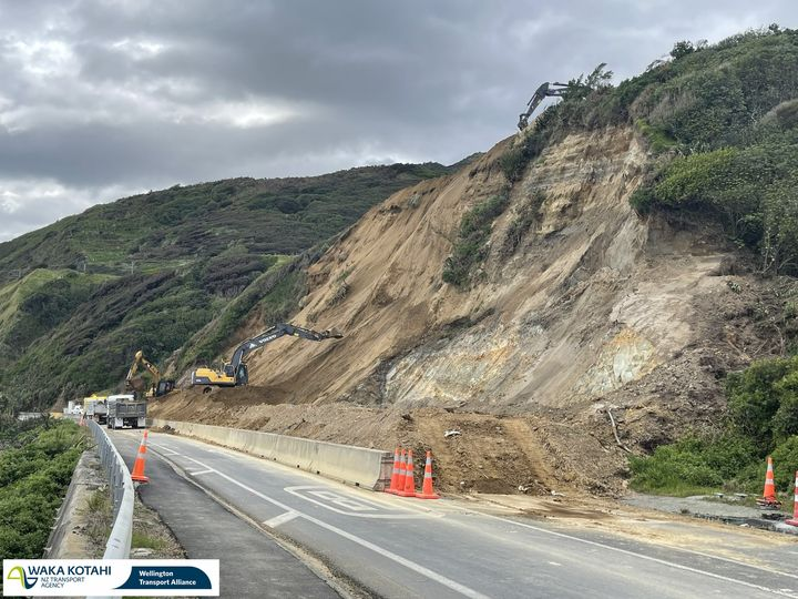
Waka Kotahi has provided a further update. It is anticipated State Highway 59 will re-open Monday 12 September if work goes smoothly.
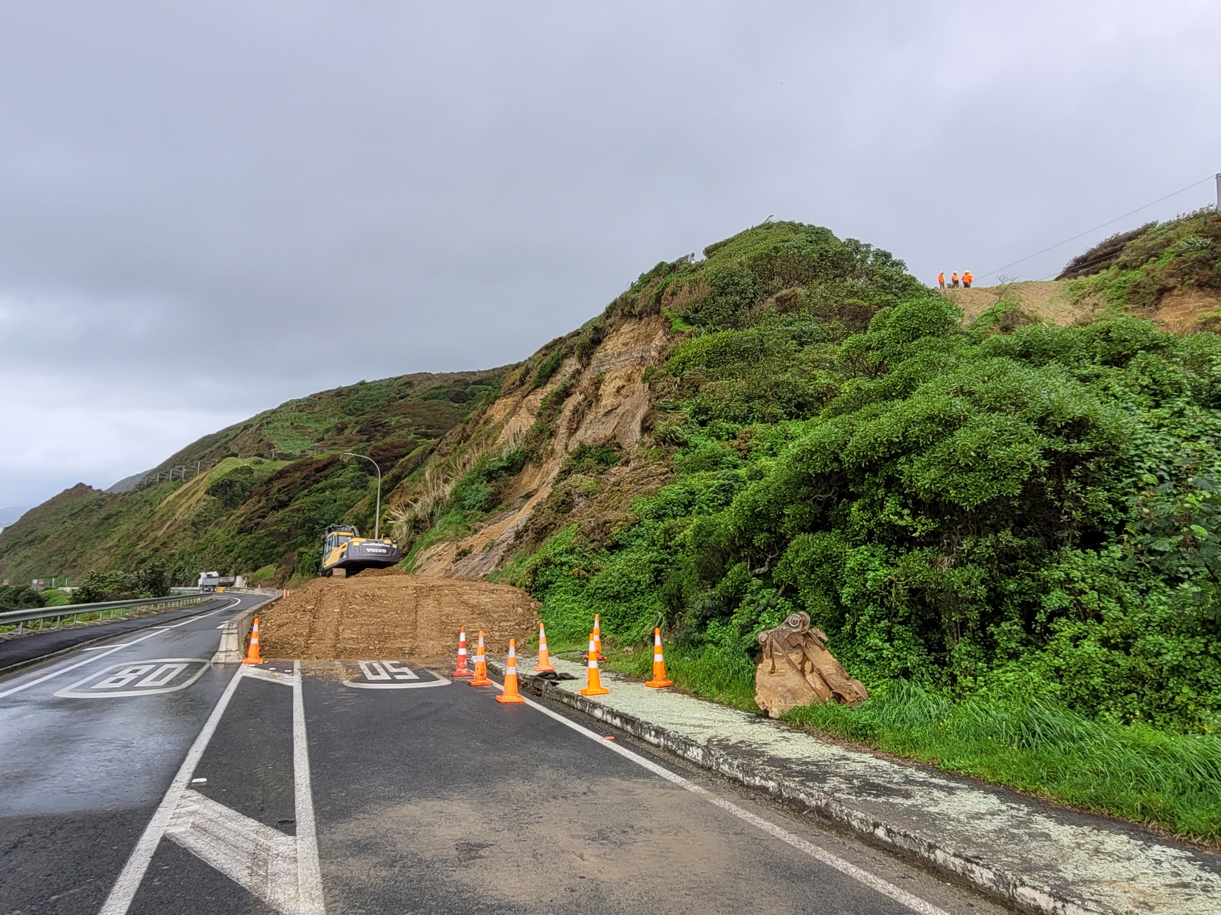
SLIP CONTROL, PUKERUA BAY HILLSIDE SAFETY PROJECT: UPDATE 2 September 2022
Since Friday 26 August,excavators have cleared the unstable overhang above the slip face and relocated the spoil using multiple trucks. Excavators are working at the top and bottom of the hillside to remove vegetation and soil to create a slope that will be stable long-term, rather than do a quick temporary clean-up. Benches (steps) are being formed along the hill to capture debris, like the benches seen on the Ngauranga Gorge hillside. Approximately 15,000 cubic metres will need be removed – that’s over 2300 truckloads of earth – with 7000 cubic metres already having been removed as at Thursday afternoon 1st September.
Multiple crews are working 10 hours a day, seven days a week to complete the safety project in as short a time as possible to minimise the impact on people’s journeys. To minimise customer impact from our maintenance activity for the next year, the closure between Pukerua Bay and Paekākāriki has been used by many crews to undertake scheduled maintenance work, such as road and barrier repairs, high risk tree removal and pruning along with drain clearing.
Work has also started on making the Pukerua Bay lookout at the top of the hill safe, where two slips have undermined footpaths.
When can the road reopen to the public?
It is hoped that the road could reopen on Monday 12 September 2022, if all goes smoothly. The safety project team continue to assess the site daily to seek potential opportunities to allow limited public access past the site. Meanwhile the road remains closed to all users.
Occasional planned and carefully coordinated escorts for any train replacement buses is occurring when needed, to maintain this vital link for people. Limited access has also been maintained between Pukerua Bay and Paekākāriki for cyclists and pedestrians who are able to use Pukerua Beach to access the path at the bottom of the hill. However, they need to exercise caution for the uneven surface and high tides.
Thanks for your patience and understanding while this essential work is carried out.
Please contact: customer@wta.nzta.govt.nz with your queries.
The next update on the re-opening of SH59 between Paekākāriki and Pukerua Bay will be provided on Friday 2 September. From Wellington NZTA:
The hillside continues to be assessed daily to ensure safe access to cyclists, vehicles and pedestrians can be restored. Residents can continue to access Pukerua Bay from the south and Paekākāriki resident access is from the north. All other road users to continue using SH1 as an alternate route.
We know these works are inconvenient and thank the community for their patience!
Follow them on Facebook or on Twitter:
Waka Kotahi has provided an update on the measures being taken to lessen the threat of further slips. This work is going to several weeks. The opening of Transmission Gully provides an opportunity to undertake remedial work that would be a far more difficult undertaking were the route still State Highway 1.
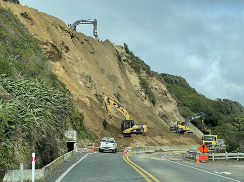
SLIP CONTROL, PUKERUA BAY HILLSIDE SAFETY PROJECT: UPDATE 26 August 2022
A hillside safety project is underway to help prevent further slips on the State Highway 59 coast road leading up to Pukerua Bay. Wellington Transport Alliance crews are removing a large overhang of soil and trees above the slip face to prevent further slips. A deep fracture in the ground behind the overhang at the top of the hill means this area is very unstable and could break away at any time.
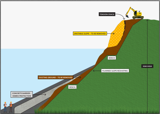
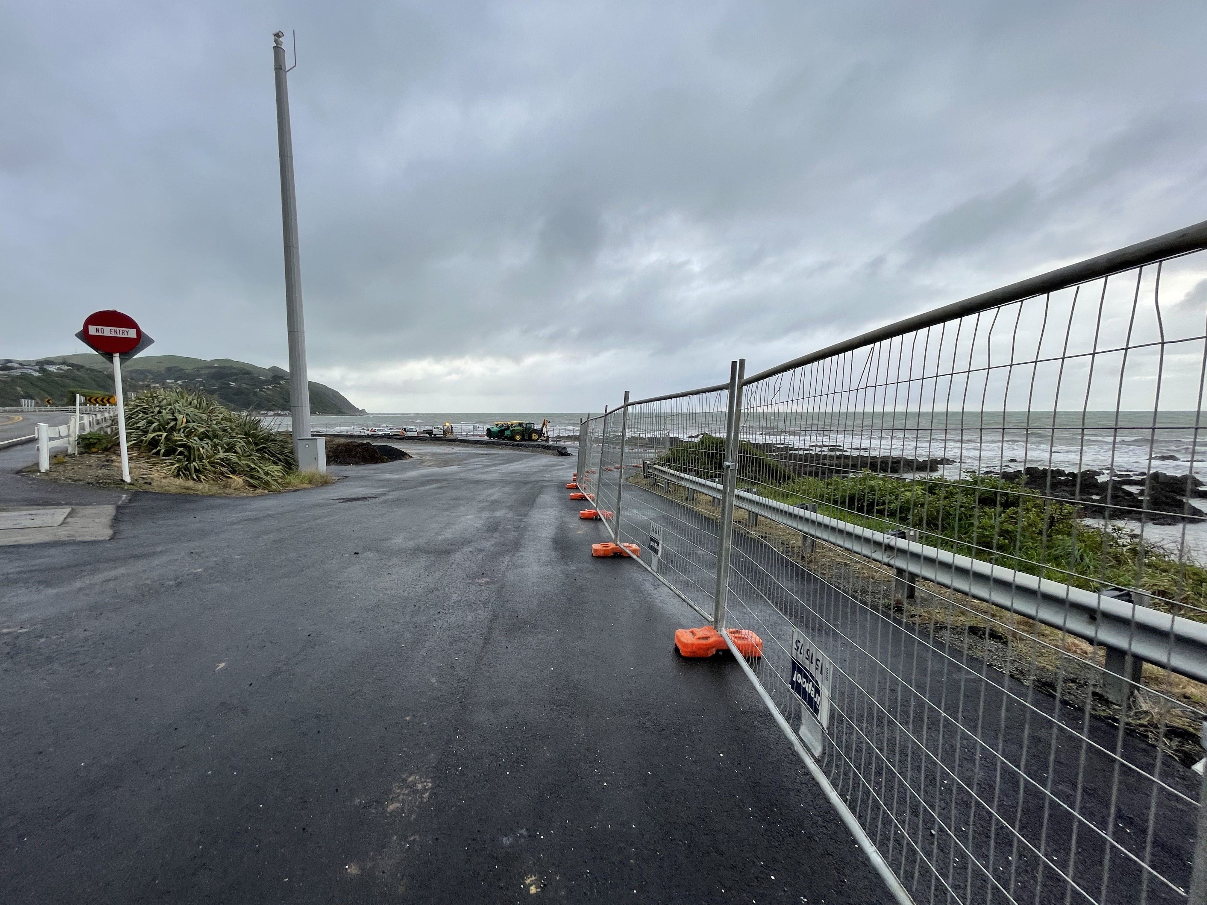
The road between Fisherman’s Table and the northern end of Pukerua Bay has become a worksite and must remain closed for everyone’s safety, not just because of the risk of a slip but because of the machines operating in the area. The safety project could take some weeks, depending on conditions. The hillside diagram, shown over the page, illustrates the overhang and the fractured ground and highlights the work that is planned to reshape the hill and prevent further slips.
Multiple works, including road and barrier repairs, tree pruning and other maintenance, are taking place to make the most of the closure.
The hillside is being inspected daily to assess when pedestrians, cyclists and vehicles can be allowed back in the area. Meanwhile, pedestrians and cyclists can use the Pukerua Bay off-road beach walking track to bypass the works but must exercise caution for high tides and weather conditions. The soft beach sand and the slope leading up to the layby at the bottom of the hill make for difficult going, particularly for cyclists. A fenced-off path has been created around the layby to keep path users safe from moving machinery. The path beside the seawall north of the layby can be used and we ask people to stay on the path and not to walk or cycle on the road as work trucks and machinery are using the area.
Please contact: customer@wta.nzta.govt.nz with your queries.
Kāinga Ora and Porirua City Council (PCC) have announced a plan to look at the Northern Growth Area to the south of Pukerua Bay as a ‘Specified Development Project’ to manage housing developments in the area. The Kāinga Ora media release is below.
Links: Kāinga Ora media release on Scoop; background on Kāinga Ora’s Specified Development Projects.
The Residents Association has prepared a statement in response:
“This is a very surprising decision and there is a lot we need to learn to come to grips with it. We know that there is pressure on housing in the region and a strong demand for it. However, we are concerned about the potential impacts on local communities, and the loss of the local voice in decisions. We have worked with Porirua City Council over many years on the 30-year Northern Growth Plan, and we are currently preparing submissions on changes to the District Plan to allow new housing developments in Pukerua Bay. We would be very concerned to lose the ability to influence decisions affecting our communities if PCC is sidelined from the decision-making process. We would expect to be included as key stakeholders in any decisions Kāinga Ora is making that will affect local communities in this area.”
…Kāinga Ora considers using Urban Development Act housing provisionsRead More »
Waka Kotahi has advised the following
Since the slip on Friday 19 August, the coast road between Fisherman’s Table and Pukerua Bay has been closed for the clean-up and to protect road users if there are further slips. It will be closed for a few more weeks for hillside safety works to reduce the risk further.
The road has become a worksite with barriers to keep people out for their safety.
Please contact: customer@wta.nzta.govt.nz with your queries.
Update from Waka Kotahi yesterday, 22 August
State Highway 59 between Paekākāriki and Pukerua Bay will remain closed until further notice.
The highway has been closed since Friday, 19 August after multiple slips. Further assessments over the weekend determined the slip site remains unpredictable. Making the site safe is a significant job, and it could take several weeks before it can reopen to traffic.
Now that work has commenced cyclists and pedestrians will not be able to pass through the wider worksite, due to the ongoing risk of material falling from the slip site and heavy vehicles and machinery moving around the wider area.
Additional barriers and fencing will be installed at the northern end of Coast Road, across the road at Fisherman’s Table and the southern end at the Pukerua Bay bottom carpark. We ask all pedestrians and cyclists to avoid the area please.
As work progresses we will review each stage to determine whether it will be safe to pass through, and we will provide updates. This work is likely to take several weeks, which we appreciate is inconvenient for locals, but your safety is our priority.
We thank you for your patience and understanding.
Porirua City Council is proposing to change the District Plan to allow housing subdivisions around Pukerua Bay. They have published a variation to the District Plan that will allow that to happen and want the community’s feedback on the proposed new plan. You can read the proposed District Plan here.
Submissions on the changes are due on Monday 12 September.
PCC has organised a ‘Friend of the Submitter’, Emily Bayliss, to help submitters. Emily is a qualified planner who is fully independent and has had no involvement in developing the Proposed District Plan.
A brief introduction from Emily is available here.
We have organised for Emily to come to a session at the RSA on Sunday 28 August, to give some advice on making submissions on the variation. This will be a good opportunity to identify the key issues to submit on, how to write a useful submission and what PCC needs to hear from us.
You can contact Emily separately by emailing FriendofSubmittersPDP@poriruacity.govt.nz or by ringing 021 532 284.
You can also talk to the Council planners about the changes. If you would like to make an appointment to talk to a member of the planning team please email dpreview@pcc.govt.nz or call on 237 5089