Shared Pathways & Cycleways

Resealing SH59 Pukerua Bay to Plimmerton Starting Sunday 11th

Waka Kotahi has advised that chipsealing State Highway 59 between Pukerua Bay and Plimmerton will be starting Sunday night 11 December

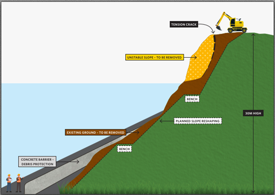
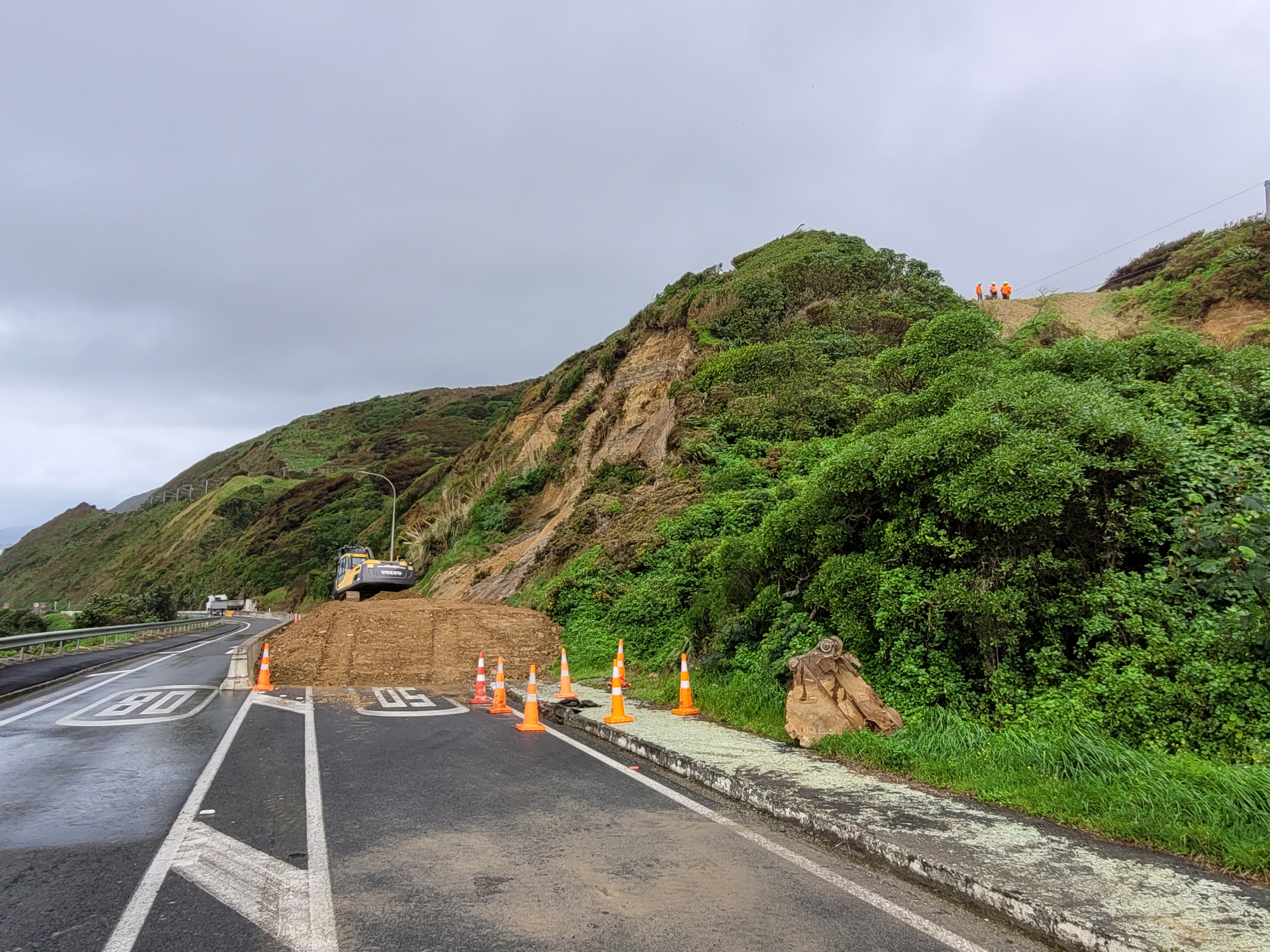
These works are programmed for next week while the Pukerua Bay slip stabilisation works are being done and traffic volumes are expected to be lower through this stretch of highway.  However you may want to factor in additional time when travelling South.

They have asked that cyclists and pedestrians use the shared path during the works for their safety.

Schedule:

Chipsealing will be done during the day, each day between 7am – 5.30pm.

Traffic management set-up will start Sunday night, 11 December at 7pm through the night. Traffic set-ups/change-overs will be at night throughout the week, for an early start the next morning.

Monday 12 December

  • The Northbound state highway will be closed from 4.30am from the Plimmerton weigh station to the merge south of Pukerua Bay.
  • Traffic will be directed to the southbound side of the highway with one lane each direction.
  • There will be stop/go traffic control at the Airlie Road intersection for access.

Tuesday 13 December

  • The Northbound state highway will be closed from 4.30am from the Plimmerton weigh station to the merge south of Pukerua Bay.
  • Traffic will be directed to the southbound side of the highway with one lane each direction.
  • There will be stop/go traffic control at the Airlie Road intersection for access.

Wednesday 14 December

  • The Southbound state highway will be closed from 4.30am from Airlie Road to north of Plimmerton roundabout
  • Traffic will be directed to the northbound side of the highway with one lane each direction.
  • There will be stop/go traffic control at the Airlie Road intersection for access.

Sweeping and line marking will be done between Tuesday and Friday.

A restricted speed limit will be in place up to 3 days and nights following the works to settle the seal.

Heavy vehicles and wide loads please use alternative routes due to the extent of these closures and the works.

Cyclists and pedestrians please use the shared path during the works.

Resealing SH59 Pukerua Bay to Plimmerton Starting Sunday 11th Read More »

Share pathway improvements

PCC has advised that work on the SH59 and Pukerua Beach Rd starts tomorrow 25 November.

https://poriruacity.govt.nz/services/parking-transport/streets-roads/

Pukerua Bay shared pathway – Stage Two improvements planned

Work to continue improving the shared pathway intersection connections through Pukerua Bay is due to start on Friday 25 November 2022 .

This work is Stage Two of a project that began last year.

The first part of this project will involve upgrades to the intersections at Pukerua Beach Rd, Haunui Rd, and SH59.

Proposed works

  • In late 2022 – improvements to the intersections of Pukerua Beach Road and SH59, and Haunui Road and Pukerua Beach Road, to make them safer for pedestrians, cyclists and turning vehicles. This work will include narrowing both intersections by building out the kerbs, new road markings, dropped kerbs and improved pathway connections to improve access for pathway users.
  • In early 2023 – improvements to the intersection of Wairaka Road and SH59 to make it safer for pedestrians, cyclists and turning vehicles. This work will include narrowing the entrance to Wairaka Road by building out the kerbs, new road markings, dropped kerbs and improved pathway connections to improve access for pathway users.

Extensive traffic management will be in place for all works so residents can expect some disruptions while the works are completed.

Porirua City Council is managing the project, which is 100 percent funded by Waka Kotahi NZ Transport Agency through its programme of highway cycle improvements.

Stage One improvements completed

Stage one of this project was completed in July 2021.

It included the following improvements:

  • Widening the zig zag pathway between Haunui Road and SH1 to make it easier for cyclists, particularly on the bends. This work included tree removal, re-asphalting the pathway and introducing holdrail in places.
  • Improved pathway directional signage from the lookout at the northern end of Pukerua Bay to Porirua Railway Station.
  • Pedestrian improvements through the northern lookout site.

*NB: In response to resident’s requests, extensive conversations were had with Waka Kotahi about installing a barrier or similar at the bottom of the zig-zag path to stop an errant rider from landing on SH59, however the barrier needed to be able to be compliant for vehicle drivers and not just provide protection for cyclists which meant that what was suitable for protecting cyclists was not safe or acceptable for the road environment and passing traffic. We have therefore opted to remove a couple of trees at the bottom of the zig-zag and widen the path to improve sightlines between path users at this pinch point.

Share pathway improvements Read More »

SH59 Pukerua Bay Hillside Stabilisation

Waka Kotahi has provided an update on the measures being taken to lessen the threat of further slips. This work is going to several weeks. The opening of Transmission Gully provides an opportunity to undertake remedial work that would be a far more difficult undertaking were the route still State Highway 1.

SLIP CONTROL, PUKERUA BAY HILLSIDE SAFETY PROJECT: UPDATE 26 August 2022

A hillside safety project is underway to help prevent further slips on the State Highway 59 coast road leading up to Pukerua Bay. Wellington Transport Alliance crews are removing a large overhang of soil and trees above the slip face to prevent further slips. A deep fracture in the ground behind the overhang at the top of the hill means this area is very unstable and could break away at any time.

Hillside slip control

The road between Fisherman’s Table and the northern end of Pukerua Bay has become a worksite and must remain closed for everyone’s safety, not just because of the risk of a slip but because of the machines operating in the area. The safety project could take some weeks, depending on conditions. The hillside diagram, shown over the page, illustrates the overhang and the fractured ground and highlights the work that is planned to reshape the hill and prevent further slips.

Multiple works, including road and barrier repairs, tree pruning and other maintenance, are taking place to make the most of the closure.

The hillside is being inspected daily to assess when pedestrians, cyclists and vehicles can be allowed back in the area. Meanwhile, pedestrians and cyclists can use the Pukerua Bay off-road beach walking track to bypass the works but must exercise caution for high tides and weather conditions. The soft beach sand and the slope leading up to the layby at the bottom of the hill make for difficult going, particularly for cyclists. A fenced-off path has been created around the layby to keep path users safe from moving machinery. The path beside the seawall north of the layby can be used and we ask people to stay on the path and not to walk or cycle on the road as work trucks and machinery are using the area.

Please contact: customer@wta.nzta.govt.nz with your queries.

SH59 Pukerua Bay Hillside Stabilisation Read More »

SH59 Cyclists and pedestrians access to Paekakariki

Waka Kotahi has advised the following

Since the slip on Friday 19 August, the coast road between Fisherman’s Table and Pukerua Bay has been closed for the clean-up and to protect road users if there are further slips. It will be closed for a few more weeks for hillside safety works to reduce the risk further.

The road has become a worksite with barriers to keep people out for their safety.

  • Please do not enter the slip control works area on the hill.
  • People using the off-road beach walking track to bypass the works can use the path beside the seawall to head north once they leave the layby at the bottom of the hill.
  • Please do not walk or cycle on the road north of the layby as work trucks are using the area and road repairs are also being done. Stick to the path.
  • A path has been created from the beach walking track around the layby at the bottom of the hill with a barrier to keep you safe from moving machinery.
  • Access via the beach walking track depends on the weather and high tides. Please exercise caution.
  • We will continually monitor the situation to see when it will safe for pedestrians and road users to return to the road past the slip area.

Please contact: customer@wta.nzta.govt.nz with your queries.

SH59 Cyclists and pedestrians access to Paekakariki Read More »

Shared Cycle & Pedestrian Pathway update

Pukerua Bay shared pathway improvements due to start September 2022

PCC has provided the following information:

Work to continue upgrading the shared pathway through Pukerua Bay is due to start next month.

This work is Stage Two of a project that began last year and will include upgrades to the intersections at Pukerua Beach Rd / Haunui Rd / SH59 and Wairaka Rd / SH59 (See layout plans 4, 5, 6). 

As budget allows, other improvements proposed will be delivered in the following order:

  • Haunui Rd zig-zag path realignment (moving bottom of path away from road) – Layout plan 8
  • Shared path widening (Haunui Rd to Pa Rd) – Layout plan 9
  • Pedestrian drop ramp on Haunui Rd (to provide a connection to the zig zag path) – Layout plan 7.

The work is due to start by mid-September (the exact start date is still being worked through).

Extensive traffic management will be in place for all works so residents can expect some disruptions for between 8 and 10 weeks while the works are completed. 

Pukerua Bay Residents living near the works will be notified via a letter in the coming weeks. 

Porirua City Council is managing the project, which is 100 percent funded by Waka Kotahi NZ Transport Agency through its programme of highway cycle improvements.

Stage One of this project was completed in July 2021.

It included the following improvements:

  • Widening the zig zag pathway between Haunui Road and SH59 to make it easier for cyclists, particularly on the bends. This work included tree removal, re-asphalting the pathway and introducing holdrail in places
  • Improved pathway directional signage from the lookout at the northern end of Pukerua Bay to Porirua Railway Station
  • Pedestrian improvements through the northern lookout site.

*NB: In response to resident’s requests, extensive conversations were had with Waka Kotahi about installing a barrier or similar at the bottom of the zig-zag path to stop an errant rider from landing on SH59, however the barrier needed to be able to be compliant for vehicle drivers and not just provide protection for cyclists which meant that what was suitable for protecting cyclists was not safe or acceptable for the road environment and passing traffic. We have therefore opted to remove a couple of trees at the bottom of the zig-zag and widen the path to improve sightlines between path users at this pinch point.

Wairaka Rd and SH59
Pukerua Beach Rd and SH59
Haunui Rd Entrance to Pathway
Haunui Rd to SH59 Pathway
From Haunui pathway to Pa Road

Shared Cycle & Pedestrian Pathway update Read More »