Waka Kotahi (NZTA) has advised that a small team will be in Pukerua Bay tomorrow Thursday night, weather permitting, to clear slips from the footpath in the area of SH 59 between Pukerua Beach Road and Wairaka Road.
This will be one of several minor slip-clearing jobs around the highway network that the team will be undertaking tomorrow night so Waka Kotahi cannot say what time the team will arrive. It should only take an hour or so.
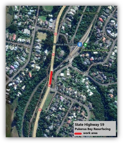
Waka Kotahi has advised that chipsealingState Highway 59 between Pukerua Bay and Plimmerton will be starting Sunday night 11 December
These works are programmed for next week while the Pukerua Bay slip stabilisation works are being done and traffic volumes are expected to be lower through this stretch of highway. However you may want to factor in additional time when travelling South.
They have asked that cyclists and pedestrians use the shared path during the works for their safety.
Schedule:
Chipsealing will be done during the day, each day between 7am – 5.30pm.
Traffic management set-up will start Sunday night, 11 December at 7pm through the night. Traffic set-ups/change-overs will be at night throughout the week, for an early start the next morning.
Monday 12 December
The Northbound state highway will be closed from 4.30am from the Plimmerton weigh station to the merge south of Pukerua Bay.
Traffic will be directed to the southbound side of the highway with one lane each direction.
There will be stop/go traffic control at the Airlie Road intersection for access.
Tuesday 13 December
The Northbound state highway will be closed from 4.30am from the Plimmerton weigh station to the merge south of Pukerua Bay.
Traffic will be directed to the southbound side of the highway with one lane each direction.
There will be stop/go traffic control at the Airlie Road intersection for access.
Wednesday 14 December
The Southbound state highway will be closed from 4.30am from Airlie Road to north of Plimmerton roundabout
Traffic will be directed to the northbound side of the highway with one lane each direction.
There will be stop/go traffic control at the Airlie Road intersection for access.
Sweeping and line marking will be done between Tuesday and Friday.
A restricted speed limit will be in place up to 3 days and nights following the works to settle the seal.
Heavy vehicles and wide loads please use alternative routes due to the extent of these closures and the works.
Cyclists and pedestrians please use the shared path during the works.
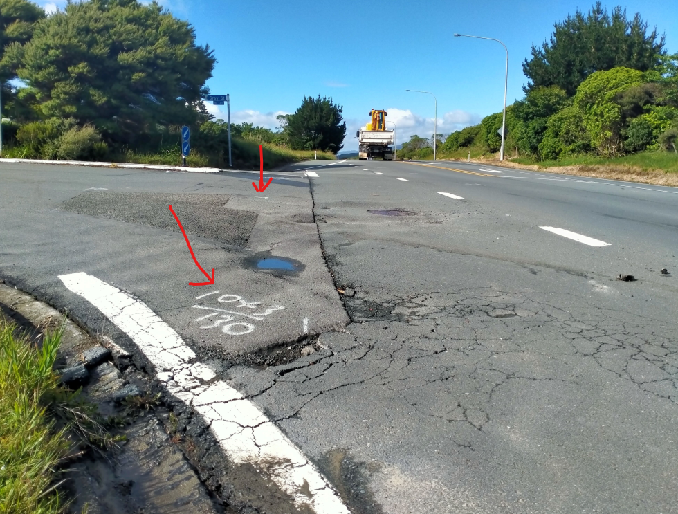
The entrance to Gray Street from SH59 is on the PCC books for remediation over summer. As anyone driving over it will know the rate of deterioration seems to be increasing. Remediation works, digging out and are dependant on the ground under the new material being dry enough to be consolidated and ready to be asphalted. The road has been marked out for some time in preparation for the works.
Pukerua Bay shared pathway – Stage Two improvements planned
Work to continue improving the shared pathway intersection connections through Pukerua Bay is due to start on Friday 25 November 2022 .
This work is Stage Two of a project that began last year.
The first part of this project will involve upgrades to the intersections at Pukerua Beach Rd, Haunui Rd, and SH59.
Proposed works
In late 2022 – improvements to the intersections of Pukerua Beach Road and SH59, and Haunui Road and Pukerua Beach Road, to make them safer for pedestrians, cyclists and turning vehicles. This work will include narrowing both intersections by building out the kerbs, new road markings, dropped kerbs and improved pathway connections to improve access for pathway users.
In early 2023 – improvements to the intersection of Wairaka Road and SH59 to make it safer for pedestrians, cyclists and turning vehicles. This work will include narrowing the entrance to Wairaka Road by building out the kerbs, new road markings, dropped kerbs and improved pathway connections to improve access for pathway users.
Extensive traffic management will be in place for all works so residents can expect some disruptions while the works are completed.
Porirua City Council is managing the project, which is 100 percent funded by Waka Kotahi NZ Transport Agency through its programme of highway cycle improvements.
Stage One improvements completed
Stage one of this project was completed in July 2021.
It included the following improvements:
Widening the zig zag pathway between Haunui Road and SH1 to make it easier for cyclists, particularly on the bends. This work included tree removal, re-asphalting the pathway and introducing holdrail in places.
Improved pathway directional signage from the lookout at the northern end of Pukerua Bay to Porirua Railway Station.
Pedestrian improvements through the northern lookout site.
*NB: In response to resident’s requests, extensive conversations were had with Waka Kotahi about installing a barrier or similar at the bottom of the zig-zag path to stop an errant rider from landing on SH59, however the barrier needed to be able to be compliant for vehicle drivers and not just provide protection for cyclists which meant that what was suitable for protecting cyclists was not safe or acceptable for the road environment and passing traffic. We have therefore opted to remove a couple of trees at the bottom of the zig-zag and widen the path to improve sightlines between path users at this pinch point.
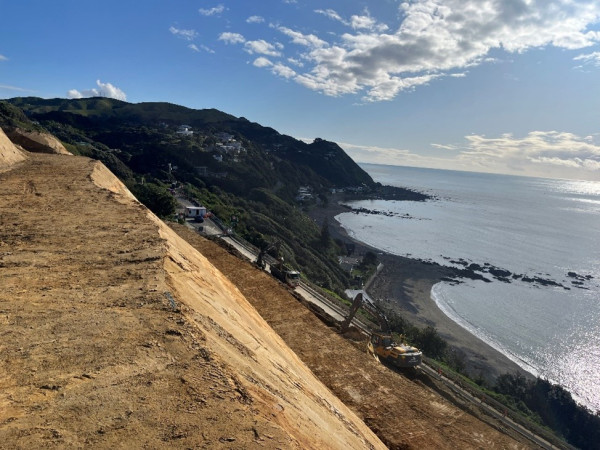
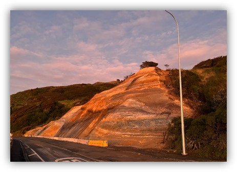
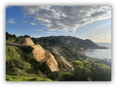
Waka Kotahi has advised that further work is to be undertaken on the slipface just noth of the Northern Lookout.
You will have noticed work restarting on the slip face north of Pukerua Bay.
Phase 2 of the coast road slip control project is about to get underway.
Two stop/goes during the daytime this week on the coast road are a taste of things to come.
The work won’t have much impact on traffic at first – just the shoulder closed with the current 50km/h speed restriction continuing on.
The Phase 2 hillside stabilisation and safety project follows the earlier work to stabilise the hillside where a large slip in late August closed the road for several weeks.
This second phase of work will strengthen the earlier slip control work and will include drilling drains to improve drainage, installing mesh and soil anchors in some areas, and spraying a concrete surface (shotcrete) over others.
December stop/go
From 6 December, stop/go traffic controlwill be in use fulltime day and night until the Christmas/New Year break, then will resume on Monday 9 January through to Friday 27 January.
Only one lane will be open and traffic lights will control the flow of vehicles.
Road users should expect delays.
However, we will be directing through-traffic to use the alternative route of SH1 Transmission Gully and leave this area of SH59 to the locals as much as possible.
There will be a break from the works over Christmas and New Year when both lanes will be open.
Pedestrians and cyclists can continue using the path beside the seawall throughout the project, though they should be aware there may be times when our traffic controllers ask them to wait.
While the contractors are busy with this hillside stabilisation work, we will take the opportunity to reseal sections of State Highway 59 between Plimmerton roundabout and Pukerua Bay.
The resealing will take approximately 4 days and is planned for early December.
We will send you more information when the resealing dates are confirmed. Regular updates will be sent on progress with the Phase 2 hillside stabilisation project.
FYI – please see the media release below on the Pukerua Bay slip site for you to share. Please contact us with any queries.
Ngā mihi,
Kerry du-Pont, Anita De Klerk & Lynsey Morgan / Customer Communications and Engagement Team Wellington Transport Alliance
21 November 2022 9:20 am | Waka Kotahi NZ Transport Agency
The work site
More work is planned to stabilise a slip face on State Highway 59, Pukerua Bay, on the Kāpiti Coast.
The section of highway was closed for around four weeks in late August and early September for slip clearing and stabilisation work.
Mark Owen, Regional Manager Wellington/Top of the South, says phase two of repair works at the site begins this week.
“It will strengthen the earlier slip control work and includes drilling drains, installing mesh and soil anchors in some areas, and spraying a concrete surface (shotcrete) over others.”
“We know regular users of the road and local residents have noticed the effect the weather has had on the earlier repairs. It was always our intention to do more work at this site. Keeping this vital transport link maintained and resilient is a priority”, Mr Owen says.
Contractors will get the work underway this week from Monday, 21 November. There will be stop/go traffic control in place for two days while concrete barriers are placed on the road shoulder to protect the work site. This should not have a major effect on traffic flows as vehicles will be able to move freely while work is done behind the barriers
The main works will begin on 6 December under fulltime stop/go traffic management. Mark Owen says this will affect road users more.
“Only one lane will be open, and traffic lights will control vehicle access. It means there will be delays on this part of State Highway 59. We recommend drivers detour via State Highway 1, Transmission Gully, while this project is underway.”
Works schedule:
21 November to 6 December
Stop/go traffic control for 2 days to install shoulder closure
Then 50km/h speed limit with road shoulder closed
Slip stabilisation works
6 December – 20 December
One laned open and stop/go traffic control will be in use full time, day and night
Slip stabilisation works
9 January – 27 January
One laned open and stop/go traffic control will be in use full time, day and night
Waka Kotahi has advised that the railway overbridge will be resurface Thursday 27th between 7:00 pm and 5:30 am (Friday Morning.
Good afternoon,
We would like to advise you of night-time resurfacing on State Highway 59 at the Pukerua Bay railway overbridge programmed for Thursday night, 27 October between 7pm and 5.30am.
Traffic will be managed with stop/go traffic control during the works.
We are again having direct access to the north, and work is continuing—so keep to the lowered speed limit. The latest from Waka Kotahi follows.
Good morning,
State Highway 59 between Pukerua Bay and Paekākāriki is now OPEN.
There are still active work sites along this corridor, so please take care and keep to the restricted speed limit for the safety of road users and crews.
SH 59 will not be re-open on Monday 12 September. There is more work to be undertaken. Waka Kotahi has provided the below up-date
Crews are working 24 hours daily to get State Highway 59 between Pukerua Bay and Paekākāriki reopened next week.
As of this morning, Friday, 9 September, 19,000 cubic metres, approximately 2500 truckloads of earth has been removed from the site as part of slip remediation, and slope benching works. Another 6,000 cubic metres, almost 800 truckloads, is to be removed this weekend.
Weather permitting, earthworks will be completed early next week.
The final part of the operation will be clearing the work site, installing edge barriers and reinstating the road before reopening safely to the public, which will take an additional 2-3 days.
On Monday, 12 September Waka Kotahi will provide an update on the expected timeframe for reopening the road.
After the success of this event at the last Local Body Elections we are doing it again. Candidates for PCC Mayor, Parirua Maori Ward, Pauatahanui General Ward and GWRC Porirua-Tawa Ward have been invited to introduce themselves to the community then face up to questions (feel free to send a question to secretary@pukeruabay.org.nz but do indicate if it’s aimed at Mayoral, Regional or PCC candidates).
The meeting will be in the School and Community Hall starting at 7 pm and finishing at 9 pm with the opportunity to mingle and talk more to the candidates after the Q & A session.