Kāinga Ora is inviting people to find out more about the proposed key features of a Specified Development Project (SDP) for the Porirua Northern Growth Area (NGA), and to provide feedback on the proposed project area, objectives, and governance body, at a drop-in session this weekend:
Where: Pukerua Bay RSA, 5 Wairaka Road, Pukerua Bay (map) When: 2pm–4pm, Saturday 16 September 2023 (ical)
Kāinga Ora – Homes and Communities is inviting the public to provide feedback on proposed key features of a potential Specified Development Project (SDP) for the Porirua Northern Growth Area (NGA).
According to Kāinga Ora, the SDP process “supports collaboration between the public and private sectors and mana whenua, and is a tool that can be used to plan and deliver complex and transformational urban development projects, helping address Aotearoa New Zealand’s housing shortage.”
SDPs allow Kāinga Ora to take over some of the rule-making powers from local councils to ensure that multiple developments are integrated with each other and the surroundings. It’s intended to avoid issues where infrastructure is inadequate for growth and funding is not sorted out before work starts. It can also make sure issues like provisions for extra public transport, roading and schools are sorted early on in the process by working with the government agencies responsible for them.
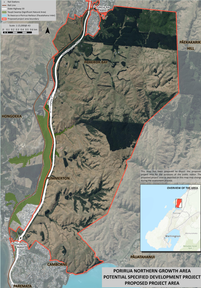
Map of Porirua Northern Growth Area
The Northern Growth Area is around 1000 hectares of greenfield land in northern Porirua, primarily made up of seven major land blocks. It is the farmland between Camborne and Pukerua Bay, mostly on the eastern side of State Highway 59, and includes the Mt Welcome deer farm and the Muri block being developed by Barber Commercial (i.e., Jennian Homes).
This area has been identified by the Porirua City Council and the Wellington Regional Leadership Committee as suitable for future urban growth. In August 2022, it was selected for assessment as a potential SDP under the Urban Development Act 2020.
Since then, Kāinga Ora has been working in partnership with Porirua City Council and Ngāti Toa Rangatira to assess whether the NGA should be recommended for establishment as an SDP.
Here is a diagram of the SDP process (PDF). Kāinga Ora in Porirua is currently at step 1 (‘Kāinga Ora carries out initial assessment’).
Kāinga Ora is inviting people to find out more about the proposed key features and provide feedback on the proposed project area, objectives, and governance body, between 31 August and 29 September 2023.
They have organised two local drop-in sessions, which we are all welcome to attend:
St Andrews Church Hall, 11 Steyne Avenue, Plimmerton, 5pm–7.30pm Thursday 7 September 2023
Pukerua Bay RSA, 5 Wairaka Road, Pukerua Bay, 2pm–4pm, Saturday 16 September 2023.
If you can’t do either of these things but would like to know more, call 0800 801 601 and the Kāinga Ora team will organise for someone to speak with you. You can direct enquiries to sdp.enquiries@kaingaora.govt.nz.
Please note, this isn’t about the proposal in the District Plan for 6-storied buildings in Pukerua Bay. That is being considered by the panel that heard submissions on the District Plan earlier this year, and we are all waiting to hear the outcome of that. That’s out of our hands now.
The fourth and final climate action workshop focused on emergency management and resilience. The previous ones looked at how we could take action to prevent climate change. This one looked at how we could be prepared for the impacts of natural disasters, which are increasingly caused by climate change.
The second and third workshops in our climate action series looked at a circular economy, the great variety of products that can be recycled, and how to make your own environmentally friendly household cleaning products.
PCC has provided an update on the slip remedial works on the track to Brendan Beach
Monitoring and geo-technical work is ongoing at the slip below the Pukerua Bay lookout on SH59.
This project is being led by Wellington Transport Alliance (WTA), in partnership with the various land owners in that area, including Porirua City Council.
In February this year, technical experts from WTA installed a number of geo-technical survey pins across the slip site. These are being regularly monitored to assess for land movement and so far there has been no significant land movement.
Remote tilt sensors have also been recently installed to provide another source of data for the slip assessment.
This information will help guide the project’s next steps regarding what further slip assessments are required and how best to manage the land in the short and long term.
In the meantime, the pathway from the lookout car park to Brendan Beach will remain closed as it is not safe for the public to use.