FYI – State Highway 59 facing longer-term closure because of slip risk
State Highway 59 between Paekākāriki and Pukerua Bay will remain closed until further notice.
The highway has been closed since Friday, 19 August after multiple slips. However, further assessments over the weekend show the slip site remains highly unstable.
Making the site safe will be a significant job, and it could take several weeks before it can reopen to traffic.
A further update on its status will be provided on Friday 26 August. Work is underway to determine the best options for fixing and reopening the highway.
Pukerua Bay residents can access from the south. Paekākāriki resident access is to the north.
All other road users should avoid the area and use State Highway 1, Transmission Gully, as an alternative route.
We want to thank road users and residents for their patience and understanding as your safety is our first priority.
FYI – State Highway 59 remains CLOSED due to slips
State Highway 59 between Paekākāriki and Pukerua Bay remains closed today, with large slips still to be cleared by roading crews.
The highway was closed yesterday and overnight after slips yesterday. This morning, further slips have come down along this section of road.
Contractors are working hard to restore the road. However, continuing rain means the chance of further slips remains.
This section of State Highway 59 will remain closed today, Saturday 20 August, and a further update on its status will be provided tomorrow morning, Sunday 21 August, or as soon as the road opens.
Pukerua Bay residents can access from the south. Paekākāriki resident access is to the north. All other road users should avoid the area and use State Highway 1, Transmission Gully, as an alternative route.
Bad weather continues to affect Wellington, with numerous slips, rockfalls, and fallen trees on roads across the region. Road users should check roads are open before they travel, drive to the conditions, watch their following distances, and be prepared for delays.
State Highway 59 between Paekākāriki and Pukerua Bay will remain closed following a further slip on the route this afternoon.
The highway was closed by a slip this morning. However, a second slip came down this afternoon, further blocking the road.
At this stage, the slope is too unstable for the route to reopen, and it will stay closed overnight. An update on its status will be provided by midday tomorrow, Saturday 20 August.
Road users should avoid the area and use State Highway 1, Transmission Gully, as an alternative route.
Bad weather continues to affect Wellington. Slips, rockfalls, and fallen trees are dangers on roads across the region. Road users should drive to the conditions, watch their following distances, and keep an eye out for road hazards.
State Highway 59 is closed between Pukerua Bay and Paekākāriki due to a slip at Arlie Road. Crews are also on-site dealing with fallen trees at Motuhara Road in Plimmerton and around Grays Road. High tide is at 2pm, and there is more rain forecast, Porirua City Council advises drivers to please take extra care and report any issues via the Antenno app (Android, Apple), or phone 04 237 5089.
Pukerua Bay shared pathway improvements due to start September 2022
PCC has provided the following information:
Work to continue upgrading the shared pathway through Pukerua Bay is due to start next month.
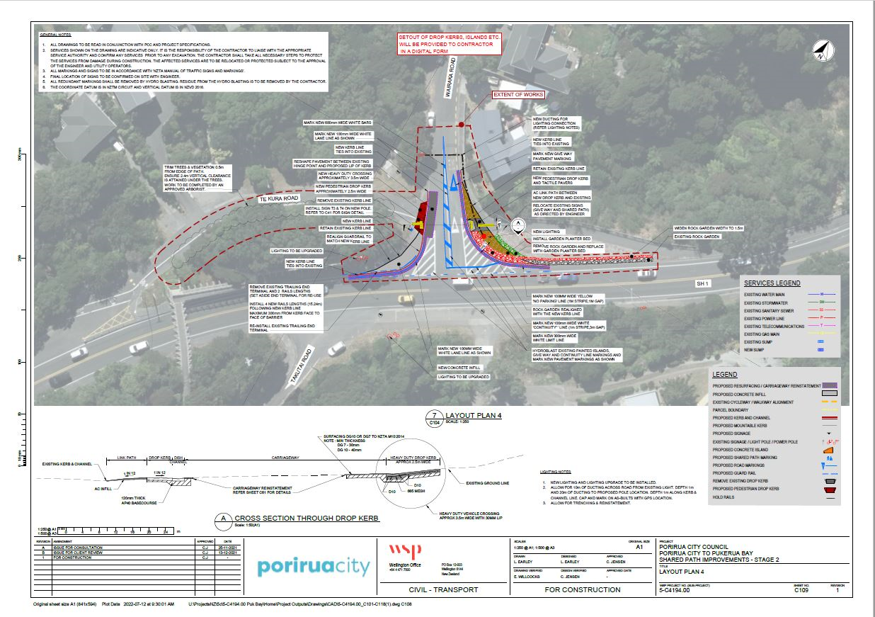
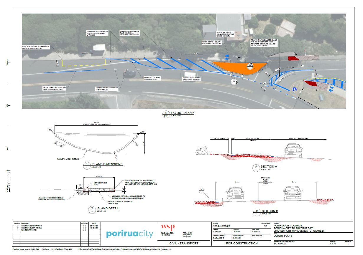
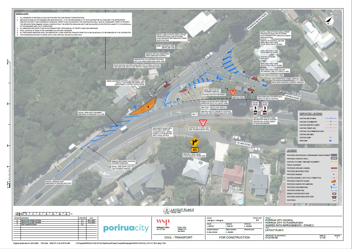
This work is Stage Two of a project that began last year and will include upgrades to the intersections at Pukerua Beach Rd / Haunui Rd / SH59 and Wairaka Rd / SH59 (See layout plans 4, 5, 6).
As budget allows, other improvements proposed will be delivered in the following order:
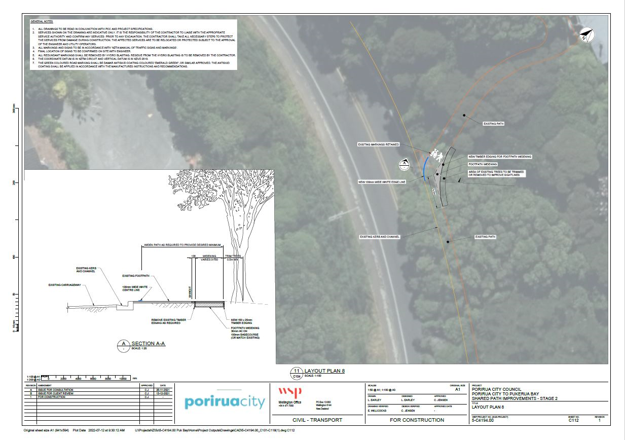
Haunui Rd zig-zag path realignment (moving bottom of path away from road) – Layout plan 8
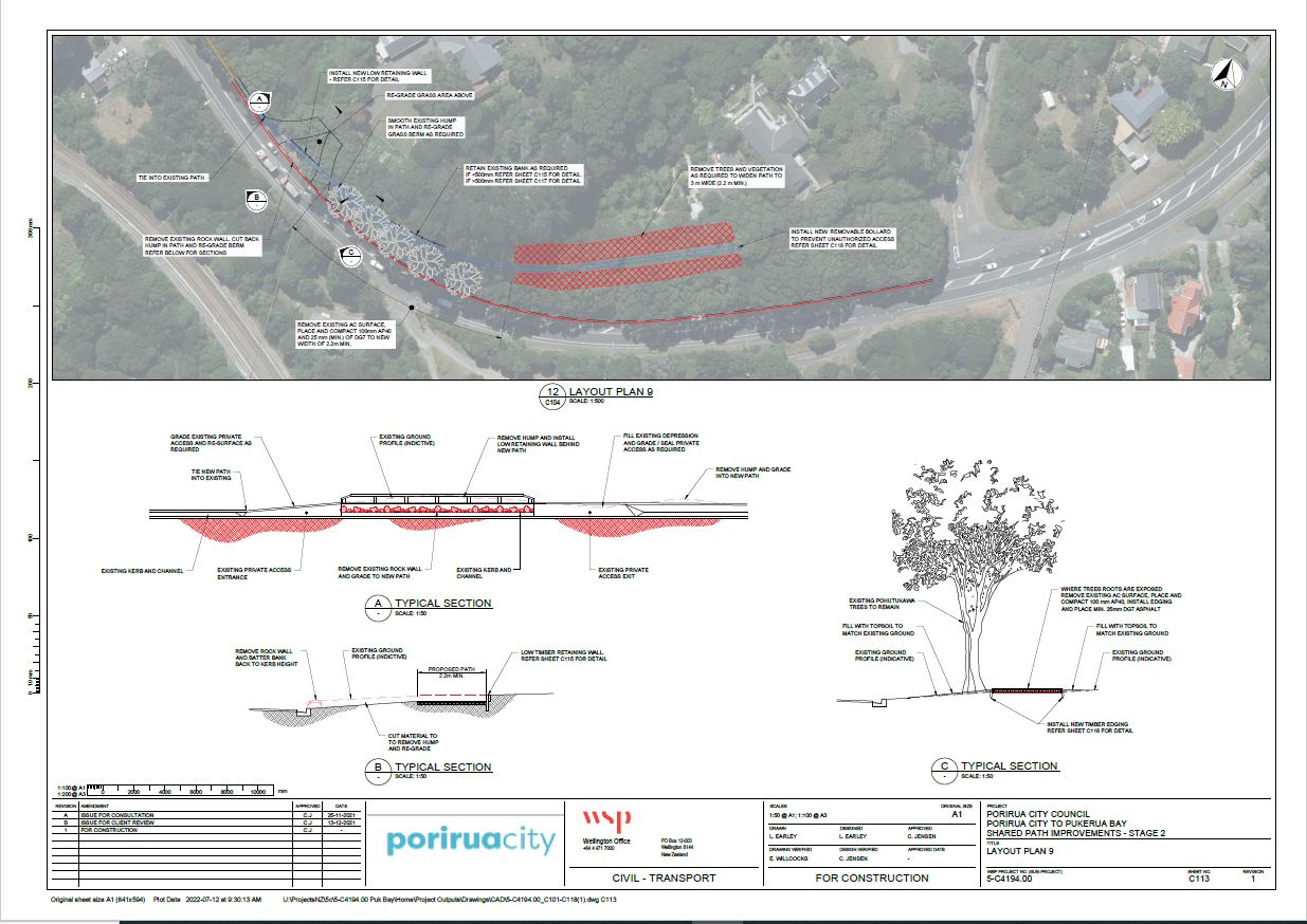
Shared path widening (Haunui Rd to Pa Rd) – Layout plan 9
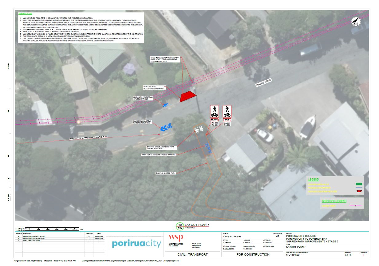
Pedestrian drop ramp on Haunui Rd (to provide a connection to the zig zag path) – Layout plan 7.
The work is due to start by mid-September (the exact start date is still being worked through).
Extensive traffic management will be in place for all works so residents can expect some disruptions for between 8 and 10 weeks while the works are completed.
Pukerua Bay Residents living near the works will be notified via a letter in the coming weeks.
Porirua City Council is managing the project, which is 100 percent funded by Waka Kotahi NZ Transport Agency through its programme of highway cycle improvements.
Stage One of this project was completed in July 2021.
It included the following improvements:
Widening the zig zag pathway between Haunui Road and SH59 to make it easier for cyclists, particularly on the bends. This work included tree removal, re-asphalting the pathway and introducing holdrail in places
Improved pathway directional signage from the lookout at the northern end of Pukerua Bay to Porirua Railway Station
Pedestrian improvements through the northern lookout site.
*NB: In response to resident’s requests, extensive conversations were had with Waka Kotahi about installing a barrier or similar at the bottom of the zig-zag path to stop an errant rider from landing on SH59, however the barrier needed to be able to be compliant for vehicle drivers and not just provide protection for cyclists which meant that what was suitable for protecting cyclists was not safe or acceptable for the road environment and passing traffic. We have therefore opted to remove a couple of trees at the bottom of the zig-zag and widen the path to improve sightlines between path users at this pinch point.
Wairaka Rd and SH59Pukerua Beach Rd and SH59Pukerua Beach Rd and SH59Haunui Rd Entrance to PathwayHaunui Rd to SH59 PathwayFrom Haunui pathway to Pa Road
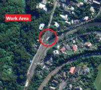
Waka Kotahi has advised there will be work tonight to repair the crash barrier at the corner of State Highway 59 and Pukerua Beach Road (map). The work is being done at night when there are fewer vehicles so it can complete the job quickly, efficiently and safely without causing major traffic delays.
Work area, corner State Highway 59 and Pukerua Beach Road (map)
Weather pemitting Porirua Council’s Contractor will be carrying out berm spraying in two areas of Pukerua Bay. The work should be completed on Friday but may spill over to Saturday.
PCC have just advised that it will be closing Pukerua Beach Road between 9am and 1pm tomorrow (Wednesday).
There will be emergency access, however residents are urged to find alternate access options or to remain at home during this time.
Given the narrow nature of Pukerua Beach Road, a full closure is required to carry out work to construct a bund on the coastal side of the road to prevent water going down the bank. This is one of the actions recommended by geotechnical advisors ENGEO.
Claire Giblin will be writing a fuller community update, which will sent out later today but wanted to alert residents to the closure as soon as possible.
Latest reports from PCC re the Pukerua Beach Road situation.
Council has a geologist on site at the moment and PCC will give updates. Its all just precautionary at this point. Its been challenging weather across the whole city this weekend. There have just been reports of some cracks on Pukerua Beach Rd so they are assessing that currently and any slip risks to Ocean Parade. . There are numerous crews out this way assessing the conditions. and a few PCC staff on the ground speaking to the residents who may be impacted. PCC wanted to reassure residents that Downer will be on site all night and PCC Emergency staff are also here should anyone need support with finding alternative accommodation (should any areas be deemed unsafe – which has not been confirmed). PCC will send an update when there more info from the crew on the ground.
I have just had a call from Claire Giblin (PCC). The latest period of rain has been causing more slips on Pukerua Beach Road, closing it. Downers are working on clearing the road.
And it appears that there have been slips on Cluny Road (Karehana Bay) with some residents evacuated from their homes.